Identify shipping in the area
The Harbour is not far from the busy shipping lanes to and from liverpool and large ships regularly anchor in the area which is known as the Lynas anchorage.
This is a useful link if you are interested in identifying and tracking shipping in the area:
ShipAIS
This is a useful link if you are interested in identifying and tracking shipping in the area:
ShipAIS
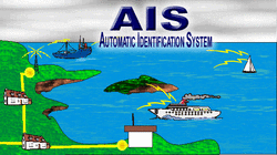
What is AIS?
The Automatic Identification System (AIS) is an automatic tracking system used on ships and by Vessel traffic services (VTS) for identifying and locating vessels by electronically exchanging data with other nearby ships and AIS Base stations. AIS information supplements marine radar, which continues to be the primary method of collision avoidance for water transport.
Using the link above you can get information on all the ships in the area that are fitted with AIS, their speed and courses and how to contact them (name, callsign, MMSI). This information is publically broadcast on VHF radio which can be picked up either by other ships or by shore based receivers.
AIS works best over a range of a few miles as the AIS signal is more or less limited to line of sight to the horizon (usually 10-20 miles). Where there are many receivers, ships can be tracked continually. However, where there are only a few receivers or it is not practical to place a receiver (eg far out to sea), then there will be gaps in the coverage. UK coverage is not complete or continuous. There are gaps in the coverage and not all areas are covered 24 hours a day.
