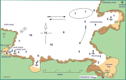
Cemaes Bay Approach

Position 53°24’N 004°28’W
Approach
From east clear Llanbadrig Head by 2 cables, and do not turn into bay from the east until Cemaes harbour is well open to avoid 1m. patch. From west, clear Wylfa, with conspic. power station and enter Bay when fully open. Cemaes (village) Bay approached to port of centre line. Anchor in Llanbadrig Cove to north-east on sand, with tidal stream across entrance, or in Porth-y-Wylfa in 2.2 metres. At W. end, anchor of Porth-y-Orgof S. of Lamb Is. in 3m-8m or dry west of island.
Dangers
Shoal patch extends 3 cables west of Llanbadrig Head. Reef off Head extends into chord of bay. Reef extends from west shore of Cemaes (village) anchorage for half cable.
Shelter
From east through south to south-west in Llanbadrig Bay. Some protection from north-east in Cemaes (village) Bay and better protection from SW than Llanbadrig. Lamb Island anchorage offers shelter round to north-west in an emergency but expect heave in a swell, sometimes severe, from all N. directions in strong winds. Porth-y-Wylfa gives protection in all winds except NW – NE.
Lights & Marks
Llanbadrig Church and Tower on headland offer marks to east of Bay. Middle Mouse provides best mark. To the west, Wylfa Nuclear Power Station is conspic., as is TV aerial on Wylfa Head. There are no navigation marks or lights. A wind farm is conspicuous inland and east of Cemaes village.
Reproduced with kind permission from Ralph Morris from "Cruising Anglesey and adjoining waters"
