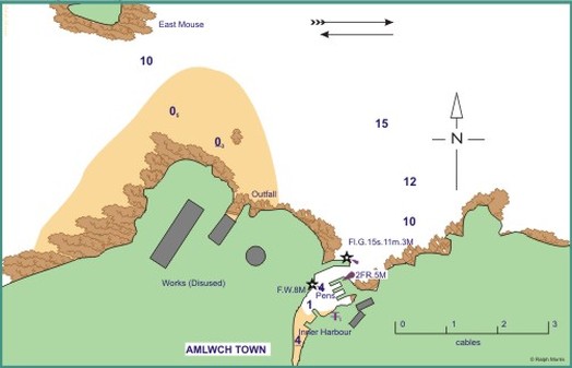
Amlwch Harbour Approach

Position 53°25’N 004°20’W
Approach
Keep outshore of East Mouse. Entrance to harbour is difficult to see - looks like continuous concrete wall. Severe swell sets across entrance, yachts need to beware of tidal set onto cliffs. Access to outer Harbour at all states of tide. Pens within harbour used by fishing boats. Secure to wall or (with permission) to fishing boats.
Dangers
Shore generally steep-to in approach. Main dangers are tidal overfalls offshore and across entrance.
Shelter
Outer harbour (built 1976) provides wall which is rough. Totally protected, but swell in strong northerlies. Pens offer excellent security and floating ‘pontoons’ (remains of offshore oil pipeline). Harbour dries to mud, limited space around fishing boats which use pens and Outer harbour. Inner Harbour, totally congested with dinghies, is only accessible by dinghy.
Lights & Marks
Breakwater Head Fl. G. 15s. 11m. 3M
Inner Breakwater Mast 2F.R.(vert),12m,5M.
Inner Harbour Post F.9m.8M
Point Lynas Lt.Ho Occ. 10s. Horn 45s
Reproduced with kind permission from Ralph Morris from "Cruising Anglesey and adjoining waters"
